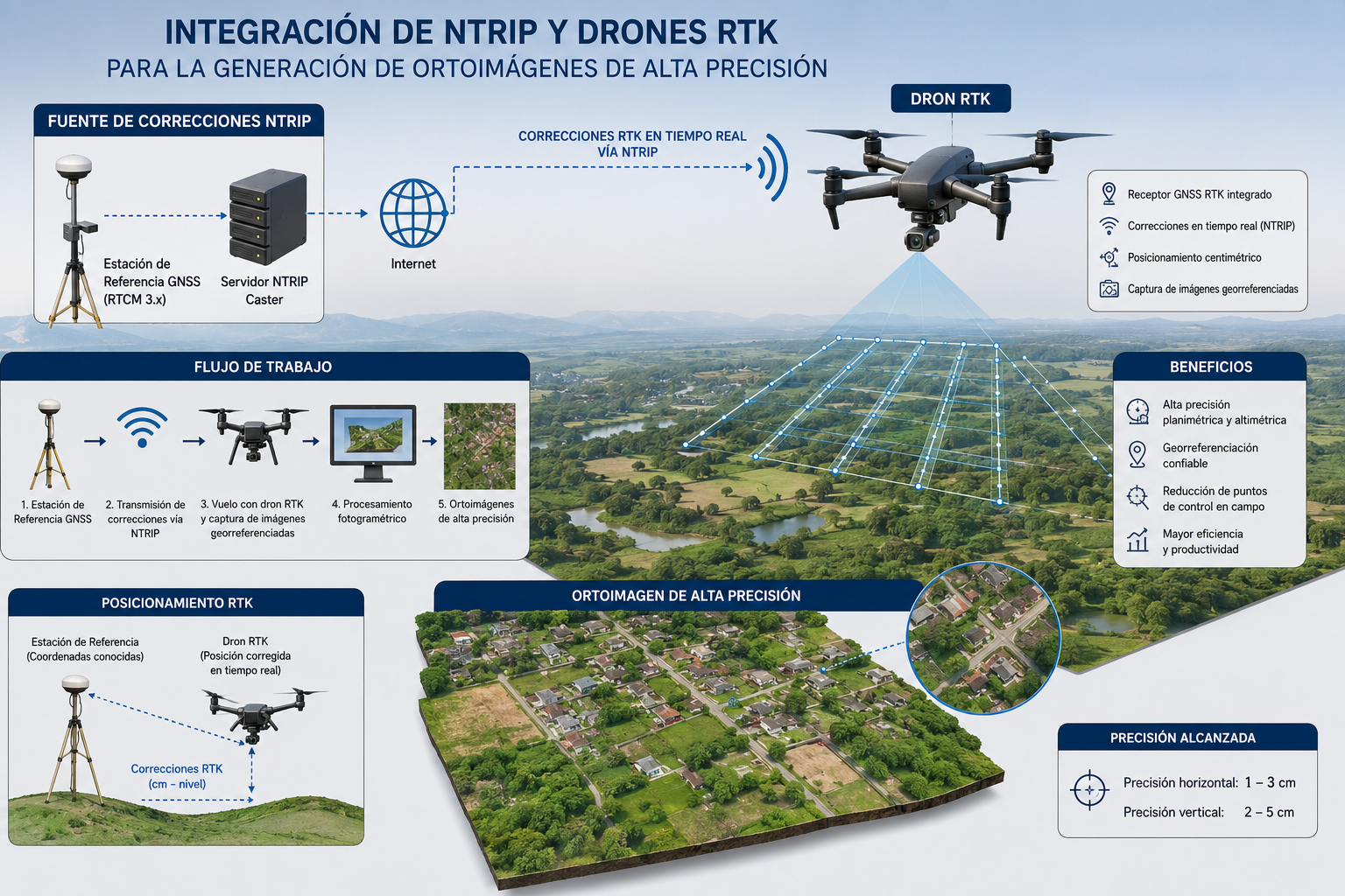
Integración de NTRIP y drones RTK para la generación de ortoimágenes de alta precisión
DOI:
https://doi.org/10.56124/sapientiae.v9i20.017Keywords:
RTK drones; Ground Control Points; Aerial photogrammetry; Surveying accuracy.Abstract
Drones with real-time positioning have transformed topographic surveys, where the optimization of time and resources is crucial in civil engineering and land management projects. Traditionally, the precise georeferencing of orthomosaics relied on Ground Control Points (GCPs), which ensure high accuracy but require complex logistics and significant field effort. As an alternative, differential corrections via NTRIP allow for a reduction in the number of GCPs, minimizing time, although the debate regarding their equivalence in accuracy remains. This study was conducted on a 2-hectare site in Guayaquil, comparing two orthomosaics: one adjusted with 8 GCPs and another generated exclusively with NTRIP. Both flights at 90 m produced orthomosaics with a GSD of 2.4 cm/pixel, validated through independent GNSS checkpoints. The results show centimeter-level accuracy in planimetry but greater vertical bias with NTRIP. It is concluded that both methodologies are comparable, although GCPs remain indispensable in critical applications.
Downloads
References
ASPRS, A. S. (marzo de 2023). ASPRS Official Standard Document. https://www.asprs.org/standards
Benassi, M., Dall'Asta, E., Diotri, F., Forlani, G., Morra di Cella, U., Roncella, R., & Santise, M. (2017). Testing UAV-based photogrammetry with RTK correction. The International Archives of the Photogrammetry, Remote Sensing and Spatial Information Sciences, XLII-2/W6, 57–63. https://doi.org/10.5194/isprs-archives-XLII-2-W6-57-2017
Camisay, M. F., Mackern, M. V., & Di Marco, L. (2014). El posicionamiento RTK–NTRIP y su vinculación con los marcos de referencia. Segundo Encuentro Investigadores de la RADU-2.014. https://revistas.um.edu.ar/index.php/index/login?source=%2Findex.php%2FRADU2%2Farticle%2Fview%2F537%2F521
Cucci, D. A., Rehak, M., & Skaloud, J. (2020). Bundle adjustment with raw GNSS observations on UAVs: Performance and stochastic modeling. ISPRS Journal of Photogrammetry and Remote Sensing, 166, 163-174. https://doi.org/10.1016/j.isprsjprs.2020.06.002
de Fátima Maciel, F., dos Reis Silva, H., Albarici, F. L., Barbosa, L. A., & Trabanco, J. L. A. (2021). Monitoramento estrutural em obras viárias utilizando a técnica RTK/NTRIP: Análise dos dados, desenvolvimento e implementação de um sistema de alerta posicional. Research, Society and Development, 10(8), e3410816846-e3410816846. https://rsdjournal.org/rsd/article/view/16846
DroneDeploy. (febrero de 2025). DroneDeploy Knowledge Base. https://www.dronedeploy.com
Emlid, B. (abril de 2024a). Emlid Blog. https://emlid.com/blog
Emlid. (abril de 2024b). Emlid Documentation. https://docs.emlid.com
Forlani, G., Diotri, F., roncella, R., & Santise, M. (2018). ISPRS Scientific Initiative: Benchmark on High Accuracy UAV Photogrammetry. The International Archives of the Photogrammetry, Remote Sensing and Spatial Information Sciences, XLII-2, 379–386. https://doi.org/10.5194/isprs-archives-XLII-2-379-2018
Geonadir. (marzo de 2025). Geonadir Articles. https://geonadir.com/articles
IGM. I. G. (s.f.). Instituto Geográfico Militar del Ecuador – REGME. ttps://www.igm.gob.ec
James, M. R., Robson, S., & Smith, M. W. (2017). Controls on post-processing accuracy and precision in UAV photogrammetry: Off-nadir imagery, camera calibration and its impact on DEM quality. Earth Surface Processes and Landforms, 42(11), 1774-1787. https://doi.org/10.1002/esp.4125
Martínez Macancela, J. &. (2023). Análisis de métodos topográficos en proyectos de infraestructura civil mediante GNSS y drones RTK. Revista Ecuatoriana de Ingeniería y Geomática, 25–34.
Padró, J.-C., Muñoz, F.-J., Ávila, L.-A., Pesquer, L., & Pons, X. (2019). Radiometric, geometric and positional accuracy assessment of DSM and orthoimages from Technologies of Remotely Piloted Aircraft Systems (RPAS) and a multi-spectral camera. International Journal of Applied Earth Observation and Geoinformation, 78, 142-154. https://doi.org/10.1016/j.jag.2019.01.018
Pix4D. (junio de 2017). Pix4D Support Documentation. https://support.pix4d.com
Sanz-Ablanedo, E., Chandler, J. H., Rodríguez-Pérez, J. R., & Ordóñez, C. (2018). Accuracy of UAV photogrammetry: Assessment with a large number of ground control points. Remote Sensing, 10(3), 447. https://doi.org/10.3390/rs10030447
Štroner, M., Urban, R., Seidl, J., Reindl, T., & Brouček, J. (2021). Photogrammetry using UAV-RTK without GCPs: Analysis of joint use of RTK and GCPs. Remote Sensing, 13(12), 2296. https://doi.org/10.3390/rs13122296
Tomaštík, J., Mokroš, M., Surový, P., Grznárová, A., & Merganič, J. (2019). UAV RTK/PPK method—An optimal solution for mapping inaccessible forested areas? Remote Sensing, 11(6), 721. https://doi.org/10.3390/rs11060721
Villacrés, C., & Cevallos, M. (2022). Evaluación de la precisión posicional horizontal y vertical en ortomosaicos generados mediante tecnología UAV-RTK/NTRIP para catastro técnico urbano en el contexto andino. Revista Tecnológica de la ESPOL, 34(2), 89-104. http://www.rte.espol.edu.ec/index.php/tecnologica/article/view/912
Zamora, J. M., Sánchez, K. O., Mora, H. E., Flores, J. L., Barrantes, M. N. S., & Pérez, E. M. (2025). Compatibilidad en soluciones GNSS aplicando corrección diferencial vía radio y NTRIP en una red urbana en Costa Rica. Ciencias Espaciales, 16(1), 47-71. https://camjol.info/index.php/CE/article/view/20508
Published
Versions
- 2026-07-15 (3)
- 2026-07-15 (2)
How to Cite
Issue
Section
License
Copyright (c) 2026 Revista Científica Multidisciplinaria SAPIENTIAE. ISSN: 2600-6030.

This work is licensed under a Creative Commons Attribution-NonCommercial-ShareAlike 4.0 International License.


2.jpg)