Evaluación integrada de susceptibilidad a inundaciones en cuenca manabita mediante herramientas geomáticas de análisis espacial
DOI:
https://doi.org/10.56124/sapientiae.v9i20.018Resumen
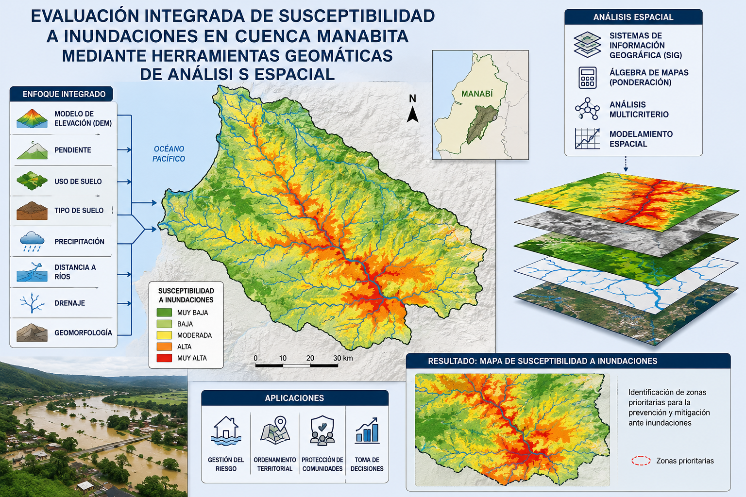
En la costa ecuatoriana, las precipitaciones intensas inducen, de manera recurrente, a la ocurrencia de episodios de inundaciones que impactan severamente sobre la población. Se evaluó la susceptibilidad a las inundaciones en la cuenca del río Garrapata mediante una aproximación integrada, basada en herramientas geomáticas. La metodología incluyó la evaluación geoespacial de factores condicionantes, su modelación multivariable mediante el Proceso de Jerarquía Analítica (AHP) y, la generación de un mapa de susceptibilidad. El modelo fue validado con un índice de confiabilidad de 0,015, evidenciándose alta exactitud en la delimitación de unidades de susceptibilidad. Se identificó que la precipitación, altitud, pendiente, proximidad a la red de drenaje y el índice de potencia del flujo son los principales factores condicionantes en la ocurrencia de inundaciones. Aproximadamente, el 45,19 % de la superficie de la cuenca se clasifica como de muy alta a alta susceptibilidad, concentrándose, principalmente, en los sectores de llanuras aluviales.
Descargas
Citas
Abdel-Wahab, A. M., Shahin, D., y Ezz, H. (2023). A sustainable solution for flood and rain hazard using remote sensing & GIS: New Cairo. The Egyptian Journal of Remote Sensing and Space Sciences, 26(4), 892–900. https://doi.org/10.1016/J.EJRS.2023.10.002
Aichi, A., Ikirri, M., Ait Haddou, M., Quesada-Román, A., Sahoo, S., Singha, C., Sajinkumar, K. S., y Abioui, M. (2024). Integrated GIS and analytic hierarchy process for flood risk assessment in the Dades Wadi watershed (Central High Atlas, Morocco). Results in Earth Sciences, 2, 100019. https://doi.org/10.1016/J.RINES.2024.100019
Al-kordi, H., Al-Amri, A., y raju, G. (2025). Landslide susceptibility mapping using geospatial, analytical hierarchy process (AHP), and binary logistic regression (BLR) techniques – A study of Wadi Habban Basin, Shabwah, Yemen. Results in Earth Sciences, 3, 100103. https://doi.org/10.1016/J.RINES.2025.100103
Ashfaq, S., Tufail, M., Niaz, A., Muhammad, S., Alzahrani, H., y Tariq, A. (2025). Flood susceptibility assessment and mapping using GIS-based analytical hierarchy process and frequency ratio models. Global and Planetary Change, 251, 104831. https://doi.org/10.1016/J.GLOPLACHA.2025.104831
Aslan, V. (2023). Evaluation of Birecik Basin Flood Detection with GIS Assisted AHP Methods. KSCE Journal of Civil Engineering, 27(7), 2891–2907. https://doi.org/10.1007/S12205-023-1271-X
Beven, K. J., y Kirkby, M. J. (1979). A physically based, variable contributing area model of basin hydrology / Un modèle à base physique de zone d’appel variable de l’hydrologie du bassin versant. Hydrological Sciences Bulletin, 24(1), 43–69. https://doi.org/10.1080/02626667909491834
Camilloni, I., Barros, V., Moreiras, S., Poveda, G., y Tomasella, J. (2020). Floods and Droughts. In Adaptation to Climate Change Risks in Ibero-American Countries — RIOCCADAPT Report (pp. 371–396). McGraw-Hill España.
Cartaya, S., y Mantuano, R. (2016). Identificación de zonas en riesgo de inundación mediante la simulación hidráulica en un segmento del Río Pescadillo, Manabí, Ecuador. Revista de Investigación, 40, 158–170.
Centre for Research on the Epidemiology of Disasters. (2025). EM-DAT: The International Disaster Database [Conjunto de datos]. Université catholique de Louvain. emdat.be
Chauhan, V., Gupta, L., y Dixit, J. (2025). Machine learning and GIS-based multi-hazard risk modeling for Uttarakhand: Integrating seismic, landslide, and flood susceptibility with socioeconomic vulnerability. Environmental and Sustainability Indicators, 26, 100664. https://doi.org/10.1016/J.INDIC.2025.100664
Chaulagain, D., Ram Rimal, P., Ngando, S. N., Nsafon, B. E. K., Suh, D., y Huh, J. S. (2023). Flood susceptibility mapping of Kathmandu metropolitan city using GIS-based multi-criteria decision analysis. Ecological Indicators, 154, 110653. https://doi.org/10.1016/J.ECOLIND.2023.110653
Choubin, B., Jaafari, A., Henareh, J., Karimi, O., y Sajedi Hosseini, F. (2025). Explainable artificial intelligence (XAI) for interpreting predictive models and key variables in flood susceptibility. Results in Engineering, 27, 105976. https://doi.org/10.1016/J.RINENG.2025.105976
Chowdhury, M. S. (2023). Modelling hydrological factors from DEM using GIS. MethodsX, 10, 102062. https://doi.org/10.1016/J.MEX.2023.102062
Chowdhury, M. S. (2024). Flash flood susceptibility mapping of north-east depression of Bangladesh using different GIS based bivariate statistical models. Watershed Ecology and the Environment, 6, 26–40. https://doi.org/10.1016/J.WSEE.2023.12.002
Chukwuma, E. C., Okonkwo, C. C., Ojediran, J. O., Anizoba, D. C., Ubah, J. I., y Nwachukwu, C. P. (2021). A GIS based flood vulnerability modelling of Anambra State using an integrated IVFRN-DEMATEL-ANP model. Heliyon, 7(9), e08048. https://doi.org/10.1016/J.HELIYON.2021.E08048
Das, S., y Gupta, A. (2021). Multi-criteria decision based geospatial mapping of flood susceptibility and temporal hydro-geomorphic changes in the Subarnarekha basin, India. Geoscience Frontiers, 12(5), 101206. https://doi.org/10.1016/J.GSF.2021.101206
DesInventar. (2025). Sistema de información de desastres [versión en español] [Sitio web]. Recuperado de https://db.desinventar.org/?lang=ES
Dutta, M., Saha, S., Saikh, N. I., Sarkar, D., y Mondal, P. (2023). Application of bivariate approaches for flood susceptibility mapping: a district level study in Eastern India. HydroResearch, 6, 108–121. https://doi.org/10.1016/J.HYDRES.2023.02.004
Dutta, P., y Deka, S. (2024). A novel approach to flood risk assessment: Synergizing with geospatial based MCDM-AHP model, multicollinearity, and sensitivity analysis in the Lower Brahmaputra Floodplain, Assam. Journal of Cleaner Production, 467, 142985. https://doi.org/10.1016/J.JCLEPRO.2024.142985
Ebrahimi, E., Araújo, M. B., y Naimi, B. (2023). Flood susceptibility mapping to improve models of species distributions. Ecological Indicators, 157, 111250. https://doi.org/10.1016/J.ECOLIND.2023.111250
Elsadek, W. M., Wahba, M., Al-Arifi, N., Kanae, S., y El-Rawy, M. (2024). Scrutinizing the performance of GIS-based analytical Hierarchical process approach and frequency ratio model in flood prediction – Case study of Kakegawa, Japan. Ain Shams Engineering Journal, 15(2), 102453. https://doi.org/10.1016/J.ASEJ.2023.102453
Gacul, L.-A., Ferrancullo, D., Gallano, R., Fadriquela, K. J., Mendez, K. J., Morada, J. R., Morgado, J. K., y Gacu, J. (2024). GIS-Based Identification of Flood Risk Zone in a Rural Municipality Using Fuzzy Analytical Hierarchy Process (FAHP). Revue Internationale de Geomatique, 33(0), 295–320. https://doi.org/10.32604/RIG.2024.055085
Garshasbi, D., Kitiphaisannon, J., Wongbumru, T., y Thanvisitthpon, N. T. (2025). Assessment of future urban flood risk of Thailand’s bangkok metropolis using geoprocessing and machine learning algorithm. Environmental and Sustainability Indicators, 25, 100559. https://doi.org/10.1016/J.INDIC.2024.100559
Guo, X., Wang, Q. J., Western, A., Ryu, D., Sharples, W., y Hou, J. (2025). Flood monitoring: A hydrologically guided method for infilling incomplete flood inundation maps derived from satellite images. Journal of Hydrology, 660, 133365. https://doi.org/10.1016/J.JHYDROL.2025.133365
Guoyi, L., Liu, J., y Shao, W. (2023). Urban flood risk assessment under rapid urbanization in Zhengzhou City, China. Regional Sustainability, 4(3), 332–348. https://doi.org/10.1016/J.REGSUS.2023.08.004
Idowu, D., Peter, B. G., Boakye, J., Cohen, S., y Carter, E. (2025). Evaluating Earth observation products for Catchment-Scale operational flood monitoring and risk management in a sparsely gauged to ungauged river basin in Nigeria. International Journal of Applied Earth Observation and Geoinformation, 138, 104445. https://doi.org/10.1016/J.JAG.2025.104445
Instituto Geográfico Militar (IGM). (2025). Catálogo de metadatos – Geoportal IGM [Sitio web]. Recuperado de https://www.geoportaligm.gob.ec/catalogo/srv/spa/catalog.search#/home
Janizadeh, S., Avand, M., Jaafari, A., Van Phong, T., Bayat, M., Ahmadisharaf, E., Prakash, I., Pham, B. T., y Lee, S. (2019). Prediction success of machine learning methods for flash flood susceptibility mapping in the Tafresh watershed, Iran. Sustainability, 11(19). https://doi.org/10.3390/su11195426
Krishnan, A., Dev, S. G. D., Arjun, S., Deepchand, V., Singh, Y., Shaji, E., y Krishnaprasad, P. K. (2025). Flood susceptibility mapping in Kali River Basin, Southern India: A GIS-based analytical hierarchy process modelling. Results in Earth Sciences, 3, 100079. https://doi.org/10.1016/J.RINES.2025.100079
Lee, S., y Rezaie, F. (2022). Data used for GIS-based Flood Susceptibility Mapping. GEO DATA, 4(1), 1–15. https://doi.org/10.22761/dj2022.4.1.001
Manopkawee, P., Mankhemthong, N., Kanthata, S., y Sooksabai, C. (2025). Quantifying Regional-Scale Flash Flood Susceptibility Using Watershed Geomorphometry-Based Approach along the High Range, West of Chiang Mai Basin, Northern Thailand. Natural Hazards Research. https://doi.org/10.1016/J.NHRES.2025.07.001
Ministerio de Agricultura y Ganadería (MAG). (2025). Geoportal – Catálogo de metadatos [Sitio web]. Recuperado de http://geoportal.agricultura.gob.ec/geonetwork/srv/spa/catalog.search#/home
Mondol, Md. F., Rifath, A. R., Muktadir, M. G., Sakib, N., Baqee, A., y Islam, Md. A. (2025). Flood Vulnerability Assessment in Jamuna River Floodplain: A Synthesis of Multi-Dimensional Vulnerability Indicators using Geospatial and Fuzzy-AHP techniques. Natural Hazards Research. https://doi.org/10.1016/J.NHRES.2025.07.002
Morales, K., Reyes, D., y Cascante, G. (2025). Determinación de amenaza a inundación, mediante el uso de sistemas de información geográfica en tres ciudades del Ecuador, a escala 1: 5000. Revista Geográfica de América Central, 74. https://doi.org/10.15359/rgac.74-10
Mshelia, Z. H., Nyam, Y. S., Moisès, D. J., y Belle, J. A. (2024). Geospatial analysis of flood risk hazard in Zambezi Region, Namibia. Environmental Challenges, 15, 100915. https://doi.org/10.1016/J.ENVC.2024.100915
Nsangou, D., Kpoumié, A., Mfonka, Z., Ngouh, A. N., Fossi, D. H., Jourdan, C., Mbele, H. Z., Mouncherou, O. F., Vandervaere, J. P., y Ndam Ngoupayou, J. R. (2022). Urban flood susceptibility modelling using AHP and GIS approach: case of the Mfoundi watershed at Yaoundé in the South-Cameroon plateau. Scientific African, 15, e01043. https://doi.org/10.1016/J.SCIAF.2021.E01043
Orosco, M., Reyes, J., Chavarría, J., y Alarcón, J. (2024). Modelación Hidrológica e Hidráulica de la Quebrada El Tejado para la Análisis de Zonas de Inundación en la Ciudad de Quito en 2023. Revista Científica INGENIAR, 7, 300–322. https://doi.org/10.46296/ig.v7i14.0219
Ozegin, K. O., y Ilugbo, S. O. (2025). Evaluation of potentially susceptible flooding areas leveraging geospatial technology with multicriteria decision analysis in Edo State, Nigeria. Natural Hazards Research, 5(1), 109–133. https://doi.org/10.1016/J.NHRES.2024.07.002
Panchal, S., y Shrivastava, A. K. (2022). Landslide hazard assessment using analytic hierarchy process (AHP): A case study of National Highway 5 in India. Ain Shams Engineering Journal, 13(3), 101626. https://doi.org/10.1016/J.ASEJ.2021.10.021
Ramotubei, T. S., Landman, W. A., Mateyisi, M. J., Nangombe, S. S., y Beraki, A. F. (2025). Response of the global ITCZ to ENSO and how the ITCZ determined from maximum precipitation compares with the surface tropical wind convergence. Environmental Development, 55, 101210. https://doi.org/10.1016/J.ENVDEV.2025.101210
Riaz, R., y Mohiuddin, M. (2025). Application of GIS-based multi-criteria decision analysis of hydro-geomorphological factors for flash flood susceptibility mapping in Bangladesh. Water Cycle, 6, 13–27. https://doi.org/10.1016/J.WATCYC.2024.09.003
Rifath, A. R., Muktadir, M. G., Hasan, M., y Islam, M. A. (2024). Flash flood prediction modeling in the hilly regions of Southeastern Bangladesh: A machine learning attempt on present and future climate scenarios. Environmental Challenges, 17, 101029. https://doi.org/10.1016/J.ENVC.2024.101029
Saaty, T.L., 1980. The Analytic Hierarchy Process. McGraw-Hill, New York, pp. 579–606. https://doi.org/10.3414/ME10-01-0028
Santana Castro, A. G., Montilla Pacheco, A. de J., y Jarre Castro, E. J. (2025). Geomática aplicada a la cartografía de desastres en el cantón Portoviejo, Manabí, Ecuador. ULEAM Bahía Magazine, 6(10), 144–152. https://doi.org/10.56124/ubm.v6i10.018
Sar, N., Ryngnga, P. K., y De, D. K. (2025). Application of the analytical hierarchy process (AHP) for flood susceptibility mapping using GIS techniques in lower reach of Keleghai River Basin, West Bengal, India. Geohazard Mechanics, 3(2), 123–135. https://doi.org/10.1016/J.GHM.2025.06.002
Secretaría Nacional de Gestión de Riesgos. (2025). Informes de situación (SitRep) por emergencias y desastres en Ecuador [2016-2025]. Recuperado de https://www.gestionderiesgos.gob.ec/informes-de-situacion-actual-por-eventos-adversos-ecuador/
Shadmaan, M. S., y Hassan, K. M. (2024). Assessment of flood susceptibility in Sylhet using analytical hierarchy process and geospatial technique. Geomatica, 76(1), 100003. https://doi.org/10.1016/J.GEOMAT.2024.100003
Shrestha, S., Dahal, D., Poudel, B., Banjara, M., y Kalra, A. (2025). Flood Susceptibility Analysis with Integrated Geographic Information System and Analytical Hierarchy Process: A Multi-Criteria Framework for Risk Assessment and Mitigation. Water, 17(7). https://doi.org/10.3390/w17070937
Singha, C., Sahoo, S., Mahtaj, A. B., Moghimi, A., Welzel, M., y Govind, A. (2025). Advancing flood risk assessment: Multitemporal SAR-based flood inventory generation using transfer learning and hybrid fuzzy-AHP-machine learning for flood susceptibility mapping in the Mahananda River Basin. Journal of Environmental Management, 380, 124972. https://doi.org/10.1016/J.JENVMAN.2025.124972
Tetteh, A. T., Kahuri, S., Yevugah, L. L., Moomen, A. W., Kwakwa, P. A., y Yakubu, I. (2026). A multi-criteria approach to fluvial flood vulnerability assessment: A case study of lower Manya Krobo municipality. Water Cycle, 7, 68–82. https://doi.org/10.1016/J.WATCYC.2025.06.001
Tetteh, A. T., Moomen, A. W., Yevugah, L. L., y Tengnibuor, A. (2024). Geospatial approach to pluvial flood-risk and vulnerability assessment in Sunyani Municipality. Heliyon, 10(18), e38013. https://doi.org/10.1016/J.HELIYON.2024.E38013
Usmani, M., Bhatti, H. M. T., Nanni, R., Bovolo, F., y Napolitano, M. (2025). Flood mapping and impact analysis by fusion of remote sensing and open geospatial data: Sindh case study. The Egyptian Journal of Remote Sensing and Space Sciences, 28(2), 357–369. https://doi.org/10.1016/J.EJRS.2025.05.001
Vallecilla, A., Delgado, D., y Méndez, W. (2022). Retrospectiva de escenarios de inundaciones en la región costera de Ecuador: Una visión de sus impactos a escala local urbana. Dominio de Las Ciencias, 8(2), 318–339. https://doi.org/10.23857/dc.v8i2.2757
Vallejo, D., Reyes, J., Tenesaca, M., y Alarcón, J. (2024). Modelación Hidráulica HEC-RAS para la Estimación y Simulación de Inundaciones en la Quebrada Cunduana, Riobamba. Revista Científica INGENIAR, 7, 344–366. https://doi.org/10.46296/ig.v7i14.0221
Varma, A. K., Dhote, A., Mathew, A., Naresh, C., y Shekar, P. R. (2025). Flood hazard zonation using remote sensing, geographic information system, and analytic hierarchy process in the Bhagirathi River Basin, Uttarakhand, India. Results in Earth Sciences, 3, 100105. https://doi.org/10.1016/J.RINES.2025.100105
Wu, Y., Ju, H., Qi, P., Li, Z., Zhang, G., y Sun, Y. (2023). Increasing flood risk under climate change and social development in the Second Songhua River basin in Northeast China. Journal of Hydrology: Regional Studies, 48, 101459. https://doi.org/10.1016/J.EJRH.2023.101459
Zafar, Z., Zubair, M., y Fahd, S. (2024). Extreme weather events and their socioeconomic impacts: A remote sensing-based analysis of flood damages. Global and Earth Surface Processes Change, 1, 100001. https://doi.org/10.1016/J.GESPCH.2024.100001
Zzaman, R. U., Nowreen, S., Billah, M., y Islam, A. S. (2021). Flood hazard mapping of Sangu River basin in Bangladesh using multi-criteria analysis of hydro-geomorphological factors. Journal of Flood Risk Management, 14(3). https://doi.org/10.1111/jfr3.12715
Publicado
Cómo citar
Número
Sección
Licencia
Derechos de autor 2026 Revista Científica Multidisciplinaria SAPIENTIAE. ISSN: 2600-6030

Esta obra está bajo una licencia internacional Creative Commons Atribución-NoComercial-CompartirIgual 4.0.


2.jpg)